Foehn Wind
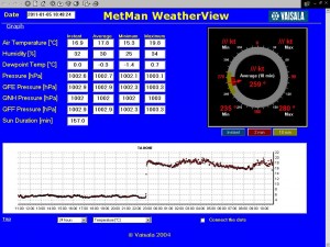
Last night we were aboard a cruise ship enjoying a BBQ is pleasant slightly chilly conditions. Just at the end when everyone was going to the presentation room to listen to Alastair and Katie’s science talk it suddenly turned very warm. Just as Alastair was doing his last slide the captain came in and said they were dragging anchor and we needed to be taken ashore straight away so he could get out of KEC. It was blowing quite a bit but everything happened without a hitch. The screenshot above shows the temperature graph over the last 24 hours showing our massive jump to 22C it is the same temperature inside as out and on my morning run I was sweating in board shorts and a t-shirt!
So how is this Foehn wind created?

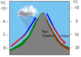
It is a very dry down slope contour hugging wind occuring in the lee of a mountain range creating a large rise in temperature.
From wikipedia…
It is a rain shadow wind that results from the subsequent adiabatic warming of air that has dropped most of its moisture on windward slopes (see orographic lift). As a consequence of the different adiabatic lapse rates of moist and dry air, the air on the leeward slopes becomes warmer than equivalent elevations on the windward slopes. Winds of this type are called “snow-eaters” for their ability to make snow melt or sublimate rapidly. This snow-removing ability is caused not only by warmer temperatures, but also the low relative humidity of the air mass having been stripped of moisture by orographic precipitation coming over the mountain(s).
From coolantarctica.com
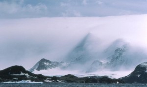
As the warm (relatively to the ice and rock) wind blows across the land, it causes snow and ice to sublime. That is to turn directly from a solid to a gas without passing through a liquid phase, so causing the cloud layer that can be seen – the same thing may happen when you open the door to your freezer and “smoke” comes out. The overall effect as seen from a distance is that the land is covered by a very large duvet. The gross contours can be seen through the cloud layer, but all of the finer detail is obscured.

Received from an “Antarctic met man”:
The Föhn effect is dominated by “blocking”. Wind, approaching a ridge, will either go up and over the ridge (normal) or come to a stop and then flow round the sides. South Georgia often experiences this latter.
Which of the two (up and over or round the sides) depends on the temperature gradient (stability), and wind speed, (Web search Froude number for more technical description). If it’s stable, the air at the ground is cold and “heavy” and wont flow up and over the top, it goes round the side. BUT, the air at the top of the ridge and just above the ridge, flows over and then down. Air aloft is already warm (because its stable, cold at the bottom), it then descends and gets even warmer and dryer …a Föhn. South Georgia has these often. If the air is just between the flow round the sides (Froude > 1) of up and over (Froude < 1 ) you get waves, which make the lenticular clouds. I suspect we will be hearing the ice cliffs on the local glaciers collapsing and have an increase in bergy bits as a result of this large increase in temperature. Looking out my window now there are lots of beautiful lenticulars clouds as well as foehn wind clouds. Northanger the yacht that left yesterday evening came back in late last night and anchored in the cove as the conditions with the Foehn wind were not pleasant.
4 Responses to “Foehn Wind”
-
Ruth Fraser January 5th, 2011 at 3:42 am
Thanks Ashley, Glad you cleared that up! It is boiling today – I have all my windows open! But rather lovely too…..
-
Mum and Dad January 5th, 2011 at 2:29 pm
My sentiments entirely, did you just type it or did you really understand everything you said from ….one not as smart as you
-
Mum and Dad January 5th, 2011 at 2:33 pm
Can you send a bit over here to Jolly Old, I was in the river today cutting the reeds
back on the shore and sure do need to warm up.XXX DAD
-
Betsy Leth January 7th, 2011 at 12:34 pm
Absolutely fascinating — when you stop doing this, you can become a meteorologist!! Hugs


